|
Java 93
After the "Riskant !" show I had
some cash to spend, so I thought it would be a good
oportunity to have some fun with my girl friend.
|
|
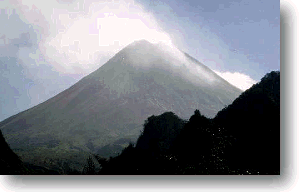
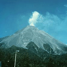
Mount Merapi,
a 2,911-meter-tall volcano on the island
of Java in Indonesia
|
(Written
in Dec 2001, eight years after the trip) Our arrival in Java
had no ambitious background at all; we were on our way to
the beaches of Bali and or flight ended in Yakkarta. So we
wanted to take advantage of our transfer and get some impressions
of Java itself. Java, Sumatra, Bali, all these are places
loaded with wild imagination of far east, jungle, pirates
and more recently environment issues. But arriving in Java
at Yakkarta airport is just as annoying as arriving in any
Mega city. You really want to leave this place as soon as
possible. Yakkarta is just too much. That's what we did, we
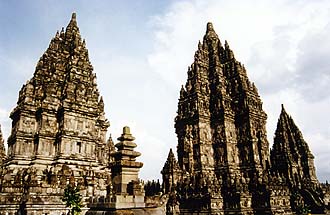
headed for Yogyakkarta to see the famous temple of Bobabadur
and PanamXXX. But once there, a dominant volcano catched my
eye, Mount Merapi !
|
|
Mount Merapi,
near the summit
|
We stayed
in a hotel, where the manager was well know as an expert in
Merapi climbing. Indeed, the dinning room was packed with
Merapi related stuff. Maps, pictures and articles about the
last eruption etc and 8 of 10 guests were staying just for
the climb. As promised, in the evening we received an one-hour
briefing about the trek and already got a bit nervous. Several
issues had to be considered: * Don't get lost at night in
the forest * Reach the tree limit before sunrise and wait
there * Always look for flying debris * Don't walk further
then the "big boulder" * Descent before 10 am, because clouds
will rise from the valley and one may not find the entrance
into the forest again To watch sunset from the summit, we
had to leave around 1am and so our group had their late supper
at midnight. To be honest, it was very exciting ! We left
around 1 am and entered the forest with our torches, very
careful not to get lost, which in fact can happen on several
occasions. Once on the trail, there are no more problems with
orientation, and only performance counts. The trail is mainly
in gullies and dried creeks, vegetation everywhere. Around
half way there is the only opportunity to rest, the bomb monument.
We reached the tree limit a bit ahead of time and stayed in
the forest, protecting ourselves from the cold. And then came
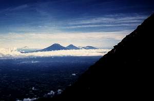
the sun... what a majestic view, the plains, the clouds and
the volcanoes in the distance.... In the briefing everything
was so clear, "just head for the big boulder". But there were
boulders everywhere. And everywhere toilet paper was flapping
in the wind, left behind from other climbers. Intended to
mark your way up, as you can find more easily your way down
its just plain confusing. So everyone went up on his own on
the 45º slope, careful with every step because the ground
has razor sharp edges. Once I catched my breath near a sulphur
fumarol, I was very very close to vomit. It's really horrible
and by the way toxic too.
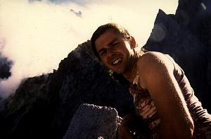
On my
quest for the "big boulder" I finally reached the summit without
knowing it. There is some scientific equipment at the top
and a very impressing view down in the crater. On the way
down I almost missed the entrance into the forest. Be very
careful here and don't loose the entrance out of sight, because
the forest is very dense and you might not get down at all.
Around early afternoon I reached the hotel. I was so broken
and exhausted, that I couldn't leave bed for two days.
Eruption
of Gunong Merapi, Indonesia
November 25, 1994
Source: volcano.und.nodak.edu
| Mount Merapi, a 2,911-meter-tall volcano
on the island of Java in Indonesia, erupted on November
22 at about 10:15 a.m. local time. Inconsistent news reports
on the number of casualties suggest that at least 34 people
were killed, several hundred were injured, and hundreds
of homes were destroyed. The eruption began with steam
explosions and ejection of rocks and gravel over the surface
of the cone. The steam plume reached about 800 meters
high. After 25 minutes of such activity, the main eruption
began and sent an ash column roughly 10 kilometers high.
An advisory was issued to warn aircraft from entering
the ash plume and being subject to engine damage and endangering
the lives of those onboard. Ash fallout was heavy as far
as 45 kilometers to the northwest of Mount Merapi. |
 |
On the ground, a pyroclastic flow of hot ash,
gas, and other suspended particles swept 6 kilometers to the
southwest down the Boyong River drainage and through Turgo
Village in the Yogyakarta District. Many of the injured suffered
severe burns from the hot gases. Most of the casualties appear
to be in two small villages. More than 6,000 people have been
evacuated from the area.
Mount Merapi has a history of violent eruptions
that led to its designation as one of the "Decade Volcanoes."
These volcanoes have been identified by the International
Association of Volcanology and Chemistry of the Earth's Interior
as requiring special study because of the danger they pose
to populated regions. Mount Merapi's last large ash eruption
occurred in 1984. A particularly devastating eruption took
place in 1930, when 1,300 were killed by an eruption here.
Another eruption, in 1976, killed 28 people and destroyed
homes of 1,176 people. Today, 50,000 people live on the southwest
flank of the volcano, and the city of Yogyakarta is only 35
kilometers away. Since 1984, Mount Merapi had erupted repeatedly
as glowing avalanches flowed from a growing lava dome, much
like the dome inside Mount St. Helens in Washington State.
These glowing avalanches, or nuee ardentes, moved down a different
river drainage towards the west.
Mount Merapi is monitored by the Volcanological
Survey of Indonesia, which mans seven volcano observatory
stations on the mountain. One of these stations had to be
abandoned because of the eruption. Starting in 1981, scientists
from the Branch of Volcanic and Geothermal Processes of the
United States Geological Survey helped train scientists and
technicians of the Volcanological Survey of Indonesia. A succession
of USGS staff spent several years in Indonesia assisting with
equipment installation and training. In more recent times,
several members of the current staff of the Volcanological
Survey of Indonesia have been trained during the summer program
at the Center for the Study of Active Volcanoes (CSAV) at
the University of Hawaii at Hilo. This summer program is specifically
aimed at training scientists from less-developed nations in
the techniques employed to monitor active volcanoes.
Each eruption teaches us more about how to
identify eruptions before they occur so that people can be
evacuated to safe ground. In the case of Merapi, we have learned
that a volcano that has been active in one area does not always
continue to erupt in the same area. The dome on the west flank
of Merapi has erupted episodically since 1984, but it was
not the location of the current eruption. This lesson can
be translated closer to home with the ongoing eruption of
Kilauea. Kilauea's eruption has been located within a confined
area along the east rift zone near Pu'u 'O'o for nearly 12
years. When changes occur, such as a pause in activity, we
expect the activity to return to the same area. However, for
the eruption near Pu'u 'O'o to end, it is likely that a different
eruption will occur along the southwest rift or at lower elevation
along the east rift zone. Like the change in activity at Merapi,
such a shift in the location of the eruption here will be
difficult to forecast because of the ongoing activity. However,
indications of such a change should be seen within the few
hours preceding the outbreak of a new eruption.
- I
|