|
21st December 2001 -
10.15 GMT
Wanna
suffer ? - 412 km to Djanet
When
leaving Illizi there's an innocent sign indicating: "412 km
to Djanet".
Believe
it, that sounds easier then it is. I met a group of 9 well-equipped,
perhaps not very experienced motor bikers. Only the good stuff,
special edition BMWs, 15.000 US-$ a piece, GPS etc. Two of
them made it to Zaouatallaz/Fort Gardel, where one motorbike
frame finally broke. There they put their stuff on a truck
and rode back to the "civilisation". The other 7 guys already
abandoned after only 50 km and went for easier tasks in Tunisia.
So why should a solo-cyclist make it, if a bunch of Paris-Dakar-Wannabes
fail ? My best guess is, that the bikers were pushing engine
and mechanics too hard with their overloaded bike. With the
bicycle this may not happen, as you can't accelerate just
with a small twist of your wrist. The key is to-be-patience.
Anyway, I was thankful for the warning and also a bit proud.
|
|
On the outskirts
of Tassili n Ajjer
Foto taken by
Otto from the Netherland, who's BMW suffered a breakdown
150 km before Djanet.
|
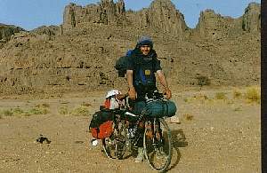
The
bike was packed with +/- 12 litres of water and food for a
week. I knew I could re-supply on sardines with tomato only
in Zaouatallaz and perhaps get some water in between. So I
tried to play it smart. I left Illizi only in the afternoon,
carrying my water supply for the day in my stomach, I had
1 litre of Coke and 1 litre of water before leaving. The first
15 or 20 km were going pretty well, but then the track became
much stonier. Now I was on a plateau, cut in small pieces
by small and big canyons, all covered with black rocks. Just
plain black everywhere, up to the horizon. Desolating. What
kind of courage was shown by the people, who entered this
hostile landscape the first time without knowing what should
be awaiting there ?
|
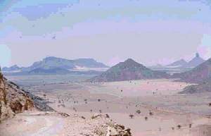
|
Descending
the Plateau near Fort Gardel
|
The
track got as bad as you might NOT be able to imagine. Big
and small stones, pebbles and always undulated. On day 2 I
just managed to make 30 km, mostly "driving" slower then walking
speed. A nightmare. Coming closer to the edge of the plateau,
the blackness vanishes, the landscape became more open and
less black, new tracks appeared everywhere. Fortunately there
is only one place to descent from the plateau so no reason
to panic. Only some km after the descent of the plateau, there
was a crossing. Bad news. I tried to find something out with
my pilot charts and the compass, but to no reveal. Then I
saw some 4WD in the distance and I choose to take the left
track, good choice. At this point, I already was 3 or 4 days
on the "road" and needed to get some water. Following the
guide book "Durch Afrika" (Därr Verlag) I knew that a guelta,
a waterhole, was close, but hidden behind some rocks. Well,
this was pretty exciting. I climbed up some rocks, maybe 20
or 30 m high, and got down on the other side. I knew, that
a twisted ankle or a stitch of a scorpion would mean big trouble,
as for sure nobody would find me here in the next week.
At
the pound, I pumped some litres of muddy water through the
ceramic filter, avoiding contact with the water; their might
be parasites, which could penetrate immediately the skin and
enter the blood circulation. Near Zauatallaz the landscape
opened wide, and I had the pleasure to impress 2 jeeps full
with tourists with my lonesome presence in the desert. Then
Zaouatallaz, which was the expected anti-climax. A view houses
and fortunately a café with some drinks and a very limited
choice of food. Coco biscuit. The sardines were already out
of date !
|
Km
|
Location |
|
|
0
|
Militarypost
Illizi |
|
| |
Guelta |
|
| |
Zaouatallaz/Fort
Gardel/Bordj el Haouares |
|
|
+/-
370
|
Begin
Tarmac |
|
|
412
|
Crossing
with mainroad to Djanet |
|
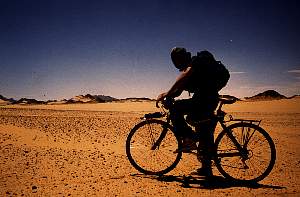
A
sandstorm was closing in. Should I leave or should I stay
? There was definitely nothing, which could hold me in Zaouatallaz
so I hoped for the better and got on the track again. The
track was very wide, but filled with sand and pebbles and
undulated like hell. Good to know; that I had the storm in
my back and it was pushing me through the sand. I even had
to brake a little. Fascinating, how the track was getting
closer to the plateau of the Tassili n Ajjer. It's one thing
to see it on a map and another to see it as a massive wall,
protected by towers and rock needles in front of you. With
dawn, the wind slowed down and finally came to a standstill,
I pulled over to a cosy depression, left by some bulldozer.
Night felt, stars came out, the moon appeared over the Tassili
and in the distance strange lights were dancing on the horizon.
Ambience enough to think of UFO. But I guess, it were just
some lost trucks or jeeps. The final day was easy going. The
track became smoother and then I touched brand-new tarmac,
circa 40 km before Djanet.
Additional Info
What
to expect:
All kind of desert landscapes and in the end the incredible
Tassili n Ajjer
How I got there:
Düsseldorf, Germany to Rome, one night at the airport,
then Rome - Algiers and some stress to get a domestic flight.
The best thing available was a flight to In Aménas
and not Illizi, as I had expected. Return flight direct Djanet
- Paris
Best
time to go:
I went there in April 1993 and it was already too hot. March
or October may be better.
Characteristics:
Large stretches of very tough tracks (stones, undulations,
a bit sand). No problem with orientation, only exception after
descent of the plateau before Zaouatallaz
- I
|